|
|
|
OBTAINING HOT SPOTS
For DMSP-OLS images an algorithm of constant thresholds was implanted; for
daytime NOAA-AVHRR images a contextual algorithm was implanted; and for NOAA- nighttime AVHRR
images, an algorithm of constant thresholds was implanted based on the first phase of the constant threshold
algorithm proposed by Flasse and Ceccato, 1996
DMSP Images
In 1998 the spatial and temporal distribution of hot spots was detected from
"crude" information of steps of the OLS sensor (Operational Linescan System) of the DMSP satellite
(Defense Meteorological Satellite Program), courtesy of NOAA-NGDC (National Oceanic and Atmospheric
Administration - National Geophysical Data Center).
Inasmuch as they were not in any conventional matrix format (for example BIP, BIL, BSQ) for
their reading, a program was carried out in CONABIO to extract bands, thereby enabling the information to be
analyzed.
The images were cut in order to obtain the portion of the passing of the satellite corresponding
to the Mexican Republic, since the complete passing was received pole to pole from the DMSP satellite. These
were co-registered (geo-referenced) with a minimum 100 control points located mainly along the coast line, by
a Lambert Conic Projection used for the projection of maps at the national level.
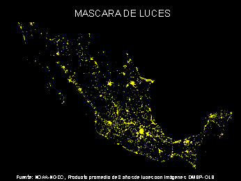
Inasmuch as the detection of hot points with this sensor is obtained directly through the response
from the sensor to light, the "photic contamination" coming from cities was eliminated by using the light
mask obtained from the sensor itself (http://julius.ngdc.noa.gov:8080/production/BIOMASS/night.html), and adding
a 6 Km "buffer" zone; thus the possibility exists of omitting hot spots close to certain cities.
For extracting the hot spots a constant threshold of 45 over channel 1 was used, the empirical
value of the sensor which can be directly translated to any physical effect, that is:
Channel 1 > 45
AVHRR Images
In 1999 and 2000 the analysis of hot spots was made with NOOA-AVHRR-LAC images (Advanced Very
High Resolution Radiometer – Local Area Coverage) both daytime and nighttime, provided daily by the Institute of
Geography of the UNAM. In 2001, CONABIO has its own antenna at its facilities consequently it directly downloads
the AVHRR images from the satellite everyday.
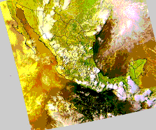
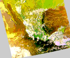
Daytime images
Source: NOAA-NGDC, CONABIO. Daytime images AHVRR. From left to right June 6 and 16, 2001, respectively.
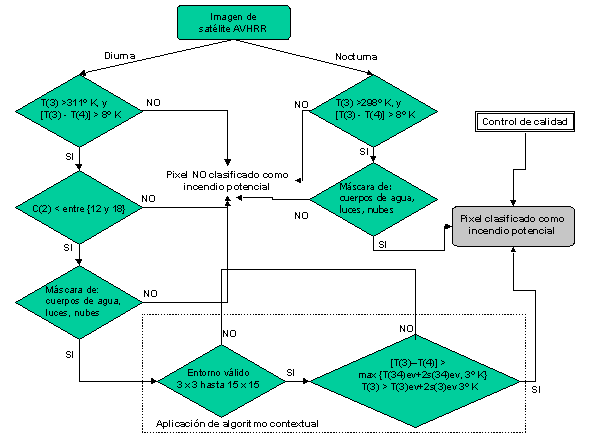
We begin with the image corrected radiometrically and georeferrenced; the algorithm is made
in two phases according to the contextual algorithm described by Flasse and Ceccato,1996, a third quality control
phase being added at CONABIO:
Note:
C(i). Represents the bi-directional reflectance factor of a channel of
AVHRR (i =1,2).
T(i). Represents the photic temperature of the channel (i = 3, 4, 5).
I. Test of fires by thresholds. Selection of pixels that could become fires.
A pixel is selected as a potential fire if:
T(3) > 311 °K, and (1)
[T(3) - T(4)] > 8 (2)
These empirical threshold values can change according to the region; see Giglio et al., 1990
and Flasse and Ceccato, 1996. The above mentioned values showed the best results in respect to the Mexican
Republic.
As mentioned above, the purpose of this phase is to extract all the pixels that may contain
fires by thresholds. The first threshold (1) is particularly low so as not to eliminate potential fires in colder
regions such as in forest environments (Flasse and Ceccato, 1996). This occurs in the case of having pixel zones
potentially determined as "fires" mixed with "cold" pixels as normally occurs. The second
threshold (2) is sufficiently high to eliminate the pixels that are not fires given the fact that they present
high brightness temperature values in both channels 3 and 4 (Kaufman et al., 1990), which unfortunately also
eliminates very hot fires (Giglio et al., 1999). At the end of each process, a review is made against the
original image; see quality control below.
After the selection of potential fires, all pixels that have been overly influenced by a high
reflectance (albedo) are eliminated, due to the fact that channel 3 of the sensor covers part of the thermal and
solar ranges "split window" of the electromagnetic spectrum. That is, in this test, those pixels that
were saturated or that contain very high values due to a high reflection instead of a high temperature are
eliminated.
The pixels are eliminated by observing the reflectance (% of albedo) in channel 2, using the
following test:
C(2) < between 12 and 18 depending on the position of the sun in regard to the
passing of the satellite.
CONABIO also decided to apply masks from digital maps available or generated from the same
source:
-
Masks of bodies of water obtained from World Databse II, Terascan, SeaSpace Corporation.
-
Mask of cities (stable lights coming from a product of 8 months of DMSP-OLS data).
-
Clouds. Analysis were conducted to extract the clouds from each image using an algorithm of detection of "simple" clouds based on the work of Saunders and Kriebel ,1988.
II. Contextual (or spatial) test of fires.
This phase confirms if the pixels detected in the preceding phase are or are not a fire. The
test is based on a comparison of the potential pixel with its immediate neighbors (test made for each one of the
potential pixels).
The test begins with a window, size 3 x 3 pixels, the center of which is the potential fire. This
window will grow up to 15 x 15 pixels if at least 25% of the pixels contained in each one of the windows qualify
(are valid).
The name valid environment is given (ev) to the set of these valid pixels. If this ratio
(25% of valid pixels) of the environment does not occur, it is decided that the pixel marked as a potential fire
is not a fire.
For each one of the windows obtained from a valid environment, the following calculations
are made:
a). A pixel marked as a potential fire in the first phase is confirmed if:
[T(3) - T(4)] > max { T(34)ev) + 2s(34)ev + 3°K } and
T(3) > T(3)ev + 2s(3)ev + 3°K
In which:
T(3)ev = Median in T(3), in the valid environment.
s(3)ev = Standard deviation in T(3) in the valid environment.
T(34)ev = Median value of [T(3) - T(4)] of the pixels in the valid environment.
s(34)ev = Standard deviation of [T(3) - T(4)] of the pixels in the valid environment.
b). To detect clouds, the following thresholds are used:
C(1) + C(2) > 60% o
T(5) < 277 °K o
[ C(1) + C(2) > 40% and T(5) < 280 °K ]
III. Quality control
Upon conclusion of the automated process experts review the results using the original
information (channels 2, 3 and 4), verifying sun glint (frequent on the coasts) and overheating from insulation.
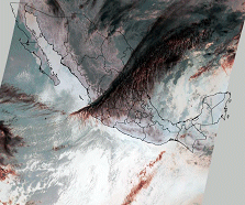
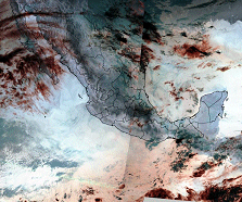
Nighttime Images
Source: NOAA-NGDC, CONABIO. Nighttime images AHVRR-LAC. From left to right March 17 and April
17, 2001, respectively.
The first phase of the contextual algorithm described by Flasse and Ceccato,1996 was used; see
the preceding chapter (Diurnas; I. Test of fires by thresholds) for the explanation.
The values of the thresholds were:
T(3) > 298 °K and (1)
T(3) - T(4) > 8 (2)
To detect clouds, the following thresholds are used:
T(5) < 272 °K and
T(3) < 298 °K (Test used to detect fires under clouds)
Below is the flow diagram of the methodology for AVHRR daytime and nighttime images.
|