|
|
||
| | Metadata Metodology | To Obtain Metadata and Cartography online | | ||
| Conabio » Geoinformation » Metadata and Digital Map Library » Metadata Metodology |
|
Metadata Metodology The objective of the studies of CONABIO, particularly in the geographic information systems area, is to evaluate, gather and generate new cartography. For the past three years our cartographic material (maps) has been increasing. Therefore, a database allowing a quick and reliable search of data for each existing map has been created and is constantly develloped. Organization of cartographic information started with a review of each directory in maps, resulting from overlays, copies, and temporarily created maps. 1200 maps were reviewed, from which those important in analysis and general query processes were extracted. In order to organize all information, metadata -"data of data"- formats already available for geographic information were reviewed; these formats include: Graphic Representation NBII Content of Standard (December, 1995), NBII Content of Standard for National Biological Information Infrastructure Metadata (December, 1995), FDGC Content of Standard for Digital Geospatial Metadata (June, 1994). The format used as a reference for information input is the Standards for Digital Geospatial Metadata NBII Metamaker (November, 1996), which incorporates NBII and FGDC standards with the following subjects: Metadata Digital Information
Fields used which meet the attributes necessary to describe cartography available in CONABIO are: Source: Standards for Digital Geospatial Metadata NBII Metamaker (November 1996) |
||||||||||||||||
|
Report Date: November 1999 1 Basic Information 1.1 Information Quote 1.2 Description
1.3 Time for Mapmaking 1.4 Status or Condition
1.3 Geographic Location
1.7 Taxonomy
1.8 Access Constraints 1.9 Use Constraints 1.10 Person to contact information » 10 Information Contacts
10.3 Contact Position:
10.5 Contact Telephone: 10.7 Contact Facsimile: 10.8 Contact Electronic Mail: 10.9 Service Hours: »
» 10 Consult Contacts
10.3 Contact Position:
10.5 Contact Telephone: 10.7 Contact Facsimile: 10.8 Contact Electronic Mail: 10.9 Service Hours: » 2 Information on data quality 2.1 Attributes Precision 2.2 Data Quality Report 2.5 Source
2.7 Taxonomic System
3 Information on Spatial Organization of Data 3.2 Data Structure (vector, raster) 3.3 Information about vector type data (point and vector)
class="Texto"3.4 Raster Object Information 3.4.1 Raster Data Type
4 Information on spatial reference 4.1 Definition of the coordinate system 4.1.2 Planar Coordinates 5 Map Attributes and Entity Information 5.1 Detailed Description of entity or table
5.1.2 Attributes
6 Information Distribution 6.1 Distributor » 10 Information Contacts
10.3 Contact Position:
10.5 Contact Telephone: 10.7 Contact Facsimile: 10.8 Contact Electronic Mail: 10.9 Service Hours: » 6.4 Form of Distribution
6.6 Technical Requirements 7 Metadata Information 7.1 Metadata Date: 7.2 Metadata Review Date: 7.4 Metadata Contact » 10 Information Contacts
10.3 Contact Position:
10.5 Contact Telephone: 10.7 Contact Facsimile: 10.8 Contact Electronic Mail: 10.9 Service Hours: » 7.5 Metadata Name 7.6 Metadata Version 7.8 Access Constraints 7.9 Use Constraints
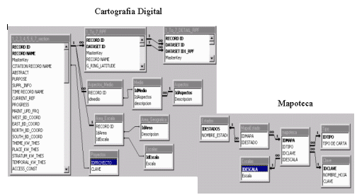
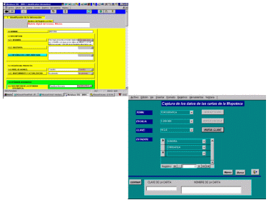
The information was organized in catalogues in Microsoft Access format and than adapted and and edited for our intranet by the Devellopment Division of Conabio.
The information is entered in the Metamaker formulars and the information contained in it is permanently updated.
|
|
Home Page | Metadata and Digital Map Library | Map Library (internal use) | Georeferencing | Satellite Images Online | Satellite Images Metadata (internal use)
For doubts, questions or comments
|